MEASURE EVALUATION PRH
Understanding GPS Coordinates and Accuracy
GPS receivers collect various types of coordinates, including Lat/Long and UTM.
2013 · 2 pages
Sign in to readA free account is required to download.
Abstract
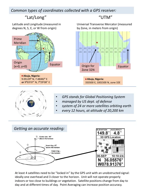
Latitude and Longitude are measured in degrees N, S, E, or W from the origin, with the origin being the Equator. The Prime Meridian serves as the reference point for East-West measurements. GPS stands for Global Positioning System, a system of 24 or more satellites orbiting the Earth, managed by the US Department of Defense. The satellites orbit the Earth at an altitude of 20,200 km, with each satellite completing an orbit every 12 hours. Abuja, Nigeria, for example, has coordinates of 333500 E, 1001500 N, zone 32E in UTM, and 9.05129⁰ N, 7.48482⁰ E in Lat/Long. For accurate readings, at least four satellites must be "locked in" by the GPS unit with an unobstructed signal. Ideally, one satellite should be overhead, and three closer to the horizon. The GPS unit will not operate properly indoors or too close to buildings or vegetation. Satellite positions change from day to day and at different times of day, which can affect accuracy. Point Averaging can increase position accuracy by combining multiple readings. To get an accurate reading, it is essential to understand the different coordinate systems used by GPS receivers. Lat/Long is given in degrees, with negative numbers sometimes used for points south of the equator or west of the Prime Meridian. UTM is in meters, with measurements taken in a specific zone. The most common datum in use today is WGS84, which is the default for GPS receivers and Google Earth. The GPS system is not perfectly accurate due to various factors, including tiny clock or orbit errors, atmospheric and weather conditions, ground interference, and poor satellite positioning. User error, such as not paying attention to settings or not accurately recording coordinates, can also exacerbate these issues. To help and plan for better accuracy, it is essential to recognize when there may be a problem, understand the limitations of the system, and take steps to mitigate these issues, such as checking settings, using point position averaging, and training users to recognize a good signal.
Related documents