USAID DEC
Baseline Scenario: Annual Precipitation (cm) for the Philippines
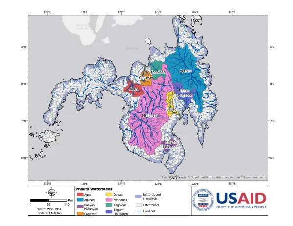
The region in question spans a latitude range of 6°N to 9°N and a longitude range of 122°E to 127°E.
30 pages
Sign in to readA free account is required to download.
Abstract
This area encompasses several provinces, including Agusan, Buayan, Cagayan, Davao, and Mindanao. The region's elevation varies, with some areas reaching as high as 2933 meters above sea level. Soil texture in the region is predominantly compact, with some areas classified as very compact, compact, porous, very porous, and most porous. The soil texture is a critical factor in determining the region's agricultural productivity and water-holding capacity. The region experiences varying levels of annual precipitation, ranging from less than 113 cm to over 886 cm. The mean daily temperature also varies, with temperatures ranging from less than 25.2°C to over 30.0°C. The mean daily temperature range is also significant, with some areas experiencing a range of less than 4.0°C to over 9.4°C. The region's hydrology is characterized by varying levels of mean annual generated flow and mean annual routed flow. The mean annual generated flow ranges from less than 2 million cubic meters to over 464 million cubic meters, while the mean annual routed flow ranges from less than 81 million cubic meters to over 8970 million cubic meters. These hydrological parameters are critical in determining the region's water resources and potential for irrigation and other water-based activities. The region's geography and climate are critical factors in determining its agricultural productivity, water resources, and potential for various economic activities. Understanding these factors is essential for developing effective strategies for sustainable development and resource management in the region.