U.S.G.S.
Latin America and the Caribbean Tsunami Preparedness and Mitigation Activities
The Caribbean is a seismically active region traversed by deep ocean trenches, underwater volcanoes, plate boundaries, and fault lines, all of which have the potential to generate catastrophic coastal hazards in a region where millions of inhabitants live near the seashore.
2014 · 2 pages
Sign in to readA free account is required to download.
Abstract
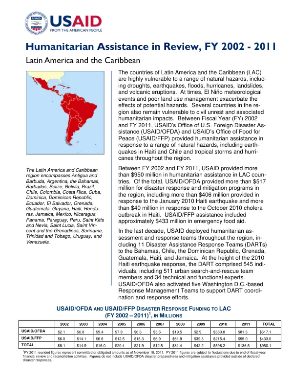
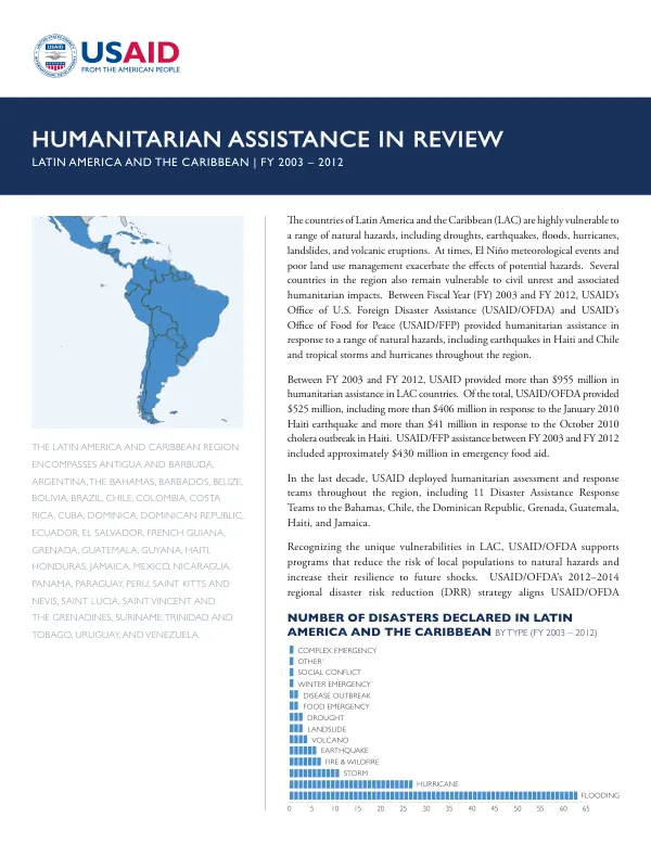
The Caribbean and its adjacent waters, including the Atlantic Ocean, have been the source region for 11 percent of the world's fatal tsunamis, with almost one hundred observed tsunamis that have impacted 23 countries, according to the Intergovernmental Oceanographic Commission (IOC) of the U.N. Educational, Scientific, and Cultural Organization (IOC-UNESCO). Efforts to establish a tsunami early warning system in the Caribbean resumed with renewed intensity following the Indian Ocean tsunami, which caused widespread death and destruction in December 2004. Since early 2005, USAID's Office of U.S. Foreign Disaster Assistance (USAID/OFDA) has supported development of the Tsunami and Other Coastal Hazards Warning System for the Caribbean and Adjacent Region (CARIBE EWS) in coordination with IOC-UNESCO. USAID/OFDA provides funding and technical assistance to improve scientific monitoring capabilities and increase tsunami awareness at the community level. Implementation of the CARIBE EWS involved a series of coordination meetings and workshops. In February 2005, USAID/OFDA facilitated a coordination meeting among Caribbean technical agencies to begin developing the warning system. This was followed by a USAID/OFDA-supported workshop hosted by the University of the West Indies Seismic Research Unit in April 2006, which brought together regional specialists to initiate information sharing and discuss equipment needs to make the warning system operational. In June 2007, more than 40 meteorologists, seismologists, and disaster managers from more than 20 countries and territories in the region attended the "Caribbean Regional Training Program in Seismology and Tsunami Warnings," funded by USAID/OFDA and implemented by the U.S. Geological Survey (USGS). Strengthening seismic and tsunami monitoring capabilities was a key component of the CARIBE EWS. In August 2006, USAID/OFDA provided $249,680 to UWI/SRC to implement the 18-month "Caribbean Tsunami Early Warning System Communications and Protocols Project." The project upgraded the Eastern Caribbean seismograph network and enhanced its capacity to detect, monitor, and provide early warning for tsunamis and related geological hazards. USAID/OFDA funding helped purchase equipment and software to enable more rapid transmission of information regarding seismic events to vulnerable communities in the Eastern Caribbean. Increasing community awareness was also a critical component of the CARIBE EWS. In September 2007, USAID/OFDA provided $475,200 to CDEMA to implement a two-year project entitled "Empowering Coastal Communities to Prepare for and Respond to Tsunamis and Other Coastal Hazards." The public awareness and education program provided the knowledge and skills to respond effectively to tsunamis and coastal hazards to approximately 2.5 million residents living on or near coastal areas in the Caribbean. The project featured two fundamental components: creating an effective model for protocols and procedures for receiving and disseminating warnings to all stakeholder agencies and potentially affected communities, and developing public education and awareness materials for CDEMA-participating states.