NORC AT THE UNIVERSITY OF CHICAGO
Paving BR-319 Policy Brief
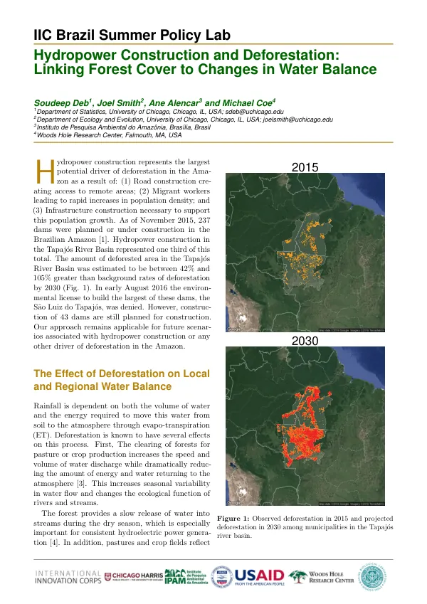
The Brazilian Amazon is a region of significant environmental concern, with approximately 75% of deforestation occurring within 50 km of major roadways.
2016 · 2 pages
Sign in to readA free account is required to download.
Abstract
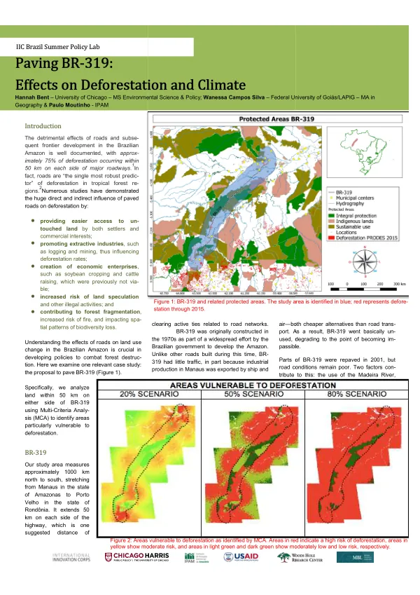
Roads are considered the single most robust predictor of deforestation in tropical forest regions. The detrimental effects of roads on the Amazon ecosystem are multifaceted, including increased access to untouched land, promotion of extractive industries, creation of economic enterprises, and increased risk of land speculation and other illegal activities. The proposal to pave BR-319, a 1,000 km highway stretching from Manaus to Porto Velho, is a case study examined in this analysis. The study area includes land within 50 km of the highway, which is a suggested distance of vulnerability to deforestation. BR-319 was originally constructed in the 1970s but has seen little traffic due to the remote location and poor road conditions. However, repaving the highway in 2001 has led to increased traffic and potential deforestation. Multi-Criteria Analysis (MCA) was used to evaluate outcomes comprising five input variables associated with deforestation: distance from BR-319, proximity to urban centers/markets, density of existing secondary roads, terrain "roughness," and location of protected areas. The analysis identified areas particularly vulnerable to deforestation, with red areas indicating the highest risk and yellow areas indicating a medium risk. The results of the analysis are displayed under three distinct scenarios: 20% deforestation, 50% deforestation, and 80% deforestation. Each scenario represents a different state of reality, spanning from most conservative to least conservative. The maps illustrating the total impact of deforestation under each scenario can also be interpreted as a likely pattern of deforestation over time if policies are not implemented to promote conservation and/or sustainable development. Historically, land surrounding BR-319 has been largely unaffected by deforestation due to its remote location and poor road conditions. However, paving BR-319 would drastically change this, resulting in huge emissions of CO2 currently stored in the forest. Analysis of above-ground biomass in the buffer area indicates that CO2 emissions could range from approximately 541 million metric tons released under the 20% deforestation scenario to approximately 2.164 billion metric tons under the 80% deforestation scenario. Comparing projected CO2 emissions from BR-319 with Brazil's annual total country emissions and INDC targets under the United Nations Framework Convention on Climate Change (UNFCCC) provides a better sense of what deforestation of this scale means for Brazil. Although deforestation in the buffer area and associated emissions would likely occur over a number of years, the emissions from this single project are significant and should be considered when evaluating the potential outcomes associated with road pavement. Studies evaluating local climactic changes from forest land to pasture and crop have observed significant increases in land surface temperature and reduction in evapotranspiration (ET). Both of these changes could have major impacts on agriculture and water availability in the region. In order to avoid deforestation, it is recommended that a regional planning process be implemented, enhanced monitoring and enforcement of illegal land-grabbing be conducted, sustainable land uses be promoted through technical assistance and credit lines, and undesignated forest be allocated as sustainable use areas or other land classifications.