USAID DEC
Potential Sites for Renewable Energy in Ghana
Ghana's renewable energy potential is significant, with various regions exhibiting favorable conditions for harnessing solar and wind power.
1 pages
Sign in to readA free account is required to download.
Abstract
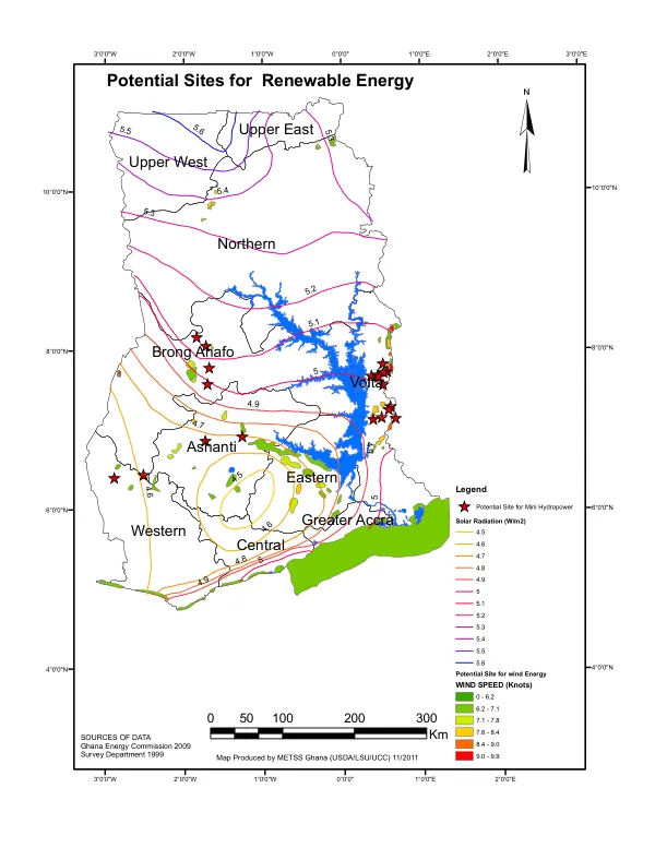
The country's geography is characterized by diverse topography, with elevations ranging from sea level to over 2,400 meters in the north. The northern regions, including Northern, Upper West, and Upper East, are generally more elevated, with average elevations exceeding 300 meters. The Volta, Ashanti, and Brong Ahafo regions are located in the southern part of the country, with average elevations ranging from 100 to 300 meters. The Western and Eastern regions are situated along the coast, with elevations generally below 100 meters. The Greater Accra region, which includes the capital city of Accra, has an average elevation of approximately 30 meters. Solar radiation levels vary across the country, with the highest values recorded in the northern regions. The Upper East region receives an average of 5.6 W/m2, while the Upper West region receives an average of 5.5 W/m2. The Volta and Ashanti regions receive an average of 5.3 W/m2, while the Brong Ahafo region receives an average of 5.2 W/m2. The Western and Eastern regions receive an average of 4.9 W/m2, while the Greater Accra region receives an average of 4.8 W/m2. Wind speed is also a critical factor in determining the potential for wind energy. The Upper East region has the highest wind speeds, with an average of 9.9 knots. The Upper West region has an average wind speed of 9.5 knots, while the Volta and Ashanti regions have an average wind speed of 8.4 knots. The Brong Ahafo region has an average wind speed of 8.1 knots, while the Western and Eastern regions have an average wind speed of 7.8 knots. The Greater Accra region has an average wind speed of 7.5 knots. Potential sites for mini hydropower and wind energy have been identified across the country. The Upper East and Upper West regions have the highest potential for mini hydropower, with several sites located along the White Volta and Black Volta rivers. The Volta and Ashanti regions also have significant potential for mini hydropower, with several sites located along the Volta River and its tributaries. The Brong Ahafo region has a moderate potential for mini hydropower, with several sites located along the Pra and Tano rivers. The data used to identify these potential sites was sourced from the Ghana Energy Commission (2009) and the Survey Department (1999). The map was produced by METSS Ghana (USDA/LSU/UCC) in 2011.