USAID DEC
Using satellite imagery to understand and promote sustainable development
Sustainable development outcomes are fundamental inputs into both research and policy.
2021 · 14 pages
Sign in to readA free account is required to download.
Abstract
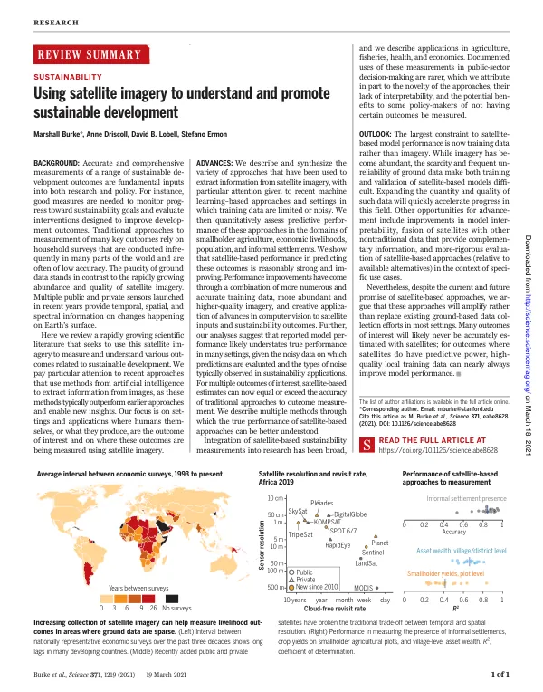
Accurate and comprehensive measurements of these outcomes are necessary to track progress toward sustainability goals and evaluate interventions designed to improve development outcomes. Traditional approaches to measurement, such as household surveys, are often infrequent and of low accuracy in many parts of the world. In contrast, satellite imagery has become abundant and improved in quality, providing temporal, spatial, and spectral information on changes happening on Earth's surface. Multiple public and private sensors have been launched in recent years, offering a range of spatial and spectral resolutions. These sensors include Landsat, MODIS, Sentinel, Planet, and others. The resolution of these sensors varies from 10 cm to 500 meters, and the revisit rate ranges from daily to monthly. The accuracy of these sensors also varies, with some achieving high accuracy and others lower accuracy. Satellite imagery has been used to measure a range of sustainable development outcomes, including smallholder yields, asset wealth, and informal settlement presence. The performance of satellite-based approaches to measurement has been assessed in various domains, including agriculture, fisheries, health, and economics. These approaches have shown reasonably strong performance in predicting outcomes, with some studies achieving high accuracy and others lower accuracy. The use of machine learning methods has improved the performance of satellite-based approaches to measurement. These methods enable the extraction of information from images and the prediction of outcomes. However, the scarcity and unreliability of ground data make it difficult to train and validate satellite-based models. Expanding the quantity and quality of ground data will accelerate progress in this field. Other areas for advancement include improving model interpretability, fusing satellites with non-traditional data, and evaluating satellite-based approaches relative to available alternatives. Despite the promise of satellite-based approaches, they will likely complement rather than replace existing ground-based data collection methods in most settings. Many outcomes of interest will not be accurately estimated with satellites, and high-quality training data can improve model performance. The use of satellite imagery to measure sustainable development outcomes has been applied in various domains, including agriculture, fisheries, health, and economics. The performance of satellite-based approaches to measurement has been assessed in these domains, with some studies achieving high accuracy and others lower accuracy. The use of machine learning methods has improved the performance of satellite-based approaches to measurement. The literature on using satellite imagery to measure sustainable development outcomes is rapidly growing, with a focus on approaches that combine satellite imagery with machine learning methods. The use of satellite imagery has become more widespread, with an estimated 713 active non-military earth observation satellites in orbit. These satellites are capturing images of Earth with unprecedented frequency, spatial, and spectral resolution.
Related documents