USAID DEC
Medium Range (10-day) Water Level Experimental Forecasts on the Major Rivers of Bangladesh
Sign inUSAID DEC
Medium Range (10-day) Water Level Experimental Forecasts on the Major Rivers of Bangladesh
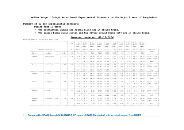
The Brahmaputra-Jamuna and Meghna river systems in Bangladesh are experiencing a rising trend in water levels.
2014 · 23 pages
Sign in to readA free account is required to download.
Abstract
The Ganges-Padma river system and the rivers around Dhaka city are also in a rising trend. This information is based on medium-range (10-day) water level experimental forecasts made on July 1, 2014. The forecasts indicate that the water levels in various rivers will continue to rise over the next 10 days. For example, the water level in the Jamuna River at Bahadurabad is expected to rise from 19.50 meters on July 1 to 18.09 meters on July 11. The water level at Sariakandi is expected to rise from 16.70 meters on July 1 to 15.71 meters on July 11. The forecasts also provide upper and lower range values for the water levels at each station. For instance, the upper range value for the water level at Aricha on the Jamuna River is 9.40 meters on July 1, while the lower range value is 7.54 meters on the same day. The mean value for the water level at Aricha is 7.58 meters on July 1. The forecasts also provide information on the water levels in other rivers, including the Padma River. The water level at Goalondo on the Padma River is expected to rise from 8.50 meters on July 1 to 7.99 meters on July 11. The water level at Bhagyakul is expected to rise from 6.30 meters on July 1 to 5.82 meters on July 11. The forecasts are based on data collected from various stations along the rivers and are intended to provide information on the water levels in the rivers over the next 10 days. The data is presented in a table format, showing the water levels at each station for each day of the forecast period. The water levels in the rivers are expected to continue rising over the next 10 days, with the Brahmaputra-Jamuna and Meghna river systems experiencing the greatest increases. The Ganges-Padma river system and the rivers around Dhaka city are also expected to experience significant increases in water levels. The forecasts are based on data collected from various stations along the rivers and are intended to provide information on the water levels in the rivers over the next 10 days. The water levels in the rivers are critical for various activities, including agriculture, fishing, and transportation. The forecasts are intended to provide information to help manage these activities and to ensure the safety of people living in the floodplains of the rivers. The data is presented in a clear and concise manner, making it easy to understand and use. The forecasts are based on a combination of historical data and current weather conditions. The data is collected from various stations along the rivers and is analyzed using sophisticated computer models. The forecasts are updated regularly to reflect changes in the weather and other factors that may affect the water levels in the rivers.