USAID
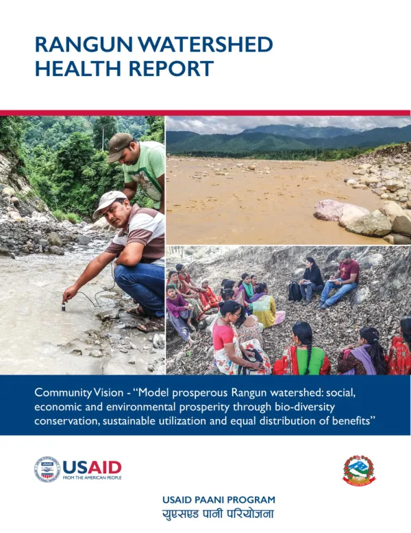
Rangun Watershed Health Report
The Rangun Watershed is an area of land that contains a common set of streams and rivers that drain into a single larger body of water, such as the Mahakali River.
2019 · 14 pages
Sign in to readA free account is required to download.
Abstract
The watershed includes more than streams and rivers; it also consists of all the people, forests, wildlife, villages, infrastructure, terrain, climate, and agriculture within the landscape. The Rangun Watershed is located in Dadeldhura and Doti Districts in southwestern Nepal, and it falls primarily within the Siwaliks along the Mahakali River basin. The watershed has many steep slopes and stretches from the mountains (about 2,500 meters) to the Tarai (about 300 meters, at the confluence with the Mahakali), creating an environment susceptible to floods, landslides, and river cutting, all of which contribute to high sedimentation and inundation downstream. These dangers also pose major threats to aquatic habitats throughout the watershed. Water is available for drinking, irrigation, and domestic uses but varies by season and location. Locally established micro-hydropower plants generate some 80.5 KW electricity, with the largest hydropower plant, Daha Gad micro-hydropower, generating 25 KW. The key threats to local water management are natural hazards, which human activities can make worse (e.g., river cutting, soil erosion, flooding, landslides), forest degradation, and deforestation due to illegal timber harvesting. The Rangun Watershed is a mosaic of ethnic diversity, with major ethnic groups including Brahmin, Chhetri, Thakuri, Dalit, Magar, Tharu, and Gurung. The watershed is home to a population of 53,109 people, with 48% male and 52% female, according to the 2015 census. The health indicators in the Rangun Watershed Health Report are grouped under larger categories of nature, wealth, and power. The nature category includes various aspects of the watershed ecosystem, including water, biodiversity, and land use. Water is a critical component of the watershed, and its condition depends on a large number of factors that affect the water cycle. Rainfall is a key factor, with data from rainfall stations in the watershed showing that rainfall decreases spatially from south to north and from the higher mountains to the lowlands. Water availability and accessibility are uneven, with several places considered water scarce. To overcome the deficit, the Parashuram Municipality has a project on drinking water. In a 2017 survey conducted by NFIWUAN, 23% of households reported spending more than 30 minutes per day to obtain water, and 82% faced difficulties due to drying water sources. Water accessibility indicates the degree of ease for users to obtain water, with obstacles including physical distance to water points and cultural barriers such as caste-based discrimination. River and lake water quality is a concern due to growing urbanization and improperly managed solid and other household wastes. Solid waste released from cluster settlements has become the main source of pollution in the Rangun Khola, with other pollution sources including runoff agro-chemicals, draining sewage, dead animal disposal, and plastics/rubbish. People reported that declining water quality may be contributing to a rise in allergies, livestock disease, and declining populations of aquatic animals. Biodiversity and habitat speak to the overall environmental strength of an area to support a wide range of animal and plant species and also human uses, such as fishing or agriculture. Land use and land cover in the Rangun Watershed are dominated by forest, with 91% of land cover, followed by cultivated land for agriculture and grazing land. Households perceive the quality of water they drink as good or excellent, with 9% of respondents reporting that the water is not good. Fish diversity in the watershed is notable, with 13 species of fish found, including Schizothorax spp, Acrossocheilus spp, Tor tor, and Barilies spp. However, respondents said that native fish populations had declined in the watershed, with reasons including a decrease in forest cover and landslides that destroy fish holes, kholas, and lakes. In particular, respondents said that Asala in the Sandani Khola and tributaries had been affected by the loss of headwater spring sources. Infrastructure and extractives have an impact on the health of the watershed, with examples including poorly designed rural roads on steep slopes that can greatly increase soil erosion and landslides, and hydropower plants that divert or impound water, restricting the amount of water available for aquatic life. Irrigation canals can also reduce the amount of water available to other farmer populations. The design, construction, and operation of infrastructure projects must be carefully planned to minimize their impact on the watershed.