USAID DEC
Semantic Segmentation of Crop Type in Africa: A Novel Dataset and Analysis of Deep Learning Methods
Sign inUSAID DEC
Semantic Segmentation of Crop Type in Africa: A Novel Dataset and Analysis of Deep Learning Methods
Crop type semantic segmentation is a critical component in understanding food systems, particularly in developing countries where ground surveys are infrequent.
8 pages
Sign in to readA free account is required to download.
Abstract
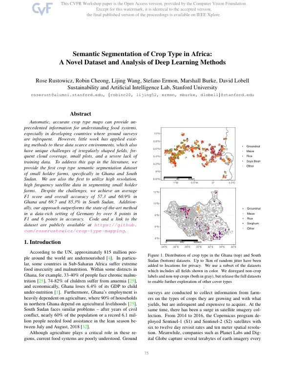
Automatic, accurate crop type maps can provide unprecedented information for decision-making, especially in regions with extreme food insecurity and malnutrition. In Sub-Saharan Africa, countries such as Ghana and South Sudan face significant challenges in food security, with nearly 60% of the population in South Sudan requiring food assistance in the lean season. The agricultural sector plays a critical role in these regions, with 74-82% of children in Ghana suffering from anemia and the country losing 6.4% of its GDP to child under-nutrition. In South Sudan, the civil war has led to a severe lack of food security, with nearly 6.1 million people requiring food assistance in the lean season. Ground surveys are infrequent and expensive, making it challenging to collect information on crop types and yields. Satellite imagery has become increasingly available, with programs such as the Sentinel-1 and Sentinel-2 satellites providing high-resolution images with six to twelve day revisit rates. Companies such as Planet Labs and Digital Globe collect terabytes of earth imagery, offering a unique opportunity to understand issues in food security. Accurate crop type segmentation can provide insights into interactions between crop types and environmental factors, facilitate crop monitoring and yield estimation, and give information on crop diversity and nutrition outcomes. To address the challenges in crop type segmentation in developing countries, researchers have developed deep-learning based semantic segmentation models to map crop types from space. These models classify each pixel as one of several different crop types, using a temporal sequence of satellite imagery over an agricultural area. The researchers explore crop type classification in Ghana and South Sudan, where this problem is particularly relevant. The researchers make several contributions, including the release of a novel dataset for crop type segmentation of small holder farms in Africa. They also develop an approach achieving state-of-the-art performance on a large crop type dataset in Germany, a data-rich regime. Additionally, they demonstrate their system achieves an average F1 score and overall accuracy of 57.3 and 60.9% in Ghana and 69.7 and 85.3% in South Sudan. The dataset used in this study consists of ground truth labels of crop fields in South Sudan and northern Ghana. The labels are geo-referenced polygons, representing an agricultural field boundary with a crop type label. The dataset includes the top four crop types in the respective regions, which make up more than 90% of the crop data. In Ghana, the focus is on Maize (51%), Groundnut (15%), Rice (14%), and Soya Bean (10%). In South Sudan, the focus is on Sorghum (67%), Maize (10%), Rice (10%), and Groundnut (10%). The input features to the model are created by mapping S1, S2, and Planet satellite imagery to time sequences. The sequences are then fed into a 2D U-Net + CLSTM model architecture, which is a type of convolutional neural network (CNN) that uses a combination of spatial and temporal information to make predictions. The model is trained on the dataset and achieves state-of-the-art performance on the crop type classification task. The results of the study demonstrate the potential of deep learning methods for crop type segmentation in developing countries. The approach achieves high accuracy and F1 scores, even in regions with limited data and challenging environmental conditions. The study highlights the importance of accurate crop type maps for decision-making in food security and agriculture, and demonstrates the potential of satellite imagery and deep learning methods for addressing these challenges.