USAID
Vegetation Class Description for the Wakhan Corridor
The Wakhan Corridor Vegetation Land Classes were delineated in a supervised land classification study.
48 pages
Sign in to readA free account is required to download.
Abstract
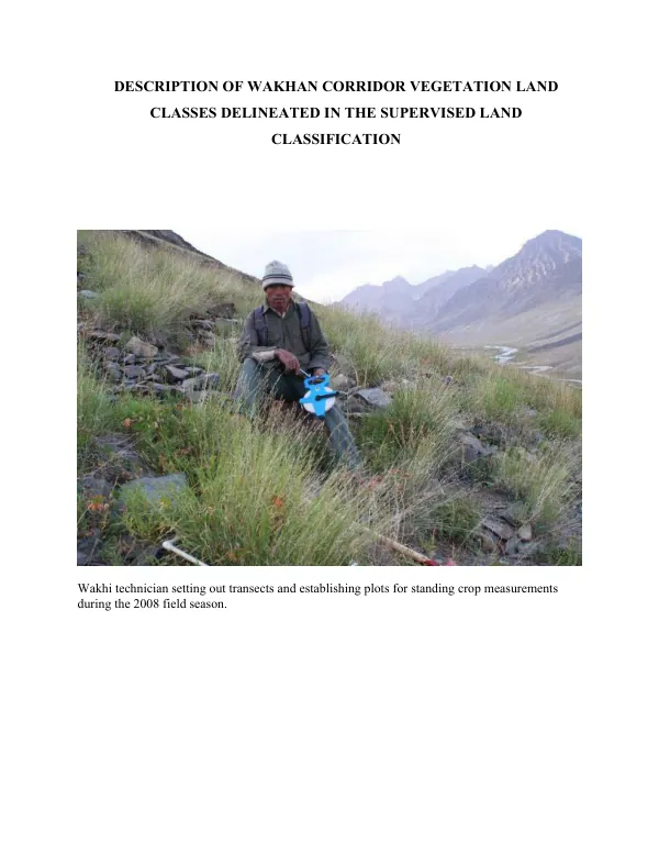
The study area is located in the Wakhan Corridor, a remote region in the Pamir Mountains of Afghanistan. The region is characterized by a diverse range of vegetation types, including forests, shrublands, grasslands, and deserts. The study employed a transect-based approach, where Wakhi technicians established plots for standing crop measurements during the 2008 field season. The data collected from these plots were used to classify the vegetation land classes into distinct categories. The classification was based on a combination of field observations, remote sensing data, and statistical analysis. The vegetation land classes identified in the study include Agriculture-Forest Pasture Mix Land Class, Forest-Shrub Land Class, Salicaceae Forest Community Type, Tall-Salix Riparian Community Type, Birch/Willow Forest Community Type, Juniper Forest Community Type, Wet Meadow and Sedge Meadow Land Classes, Salt Grass Land Class, Artemisia Steppe Land Class, Artemisia/Festuca-Stipa Community Type, Artemisia Subshrub Land Class, Artemisia/Acantholimon Community Type, Low Sage (Artemisia) Land Class, Cold Desert Land Class, Krascheninnikovia lanata Cover Type, Artemisia Cold Desert Community Type, Alpine Land Classes, Alpine Grass Land Class, Alpine Forb Land Class, Festuca Community Cover Type (Transition Phase), and Stipa Community Type Transition. The study found that the Agriculture-Forest Pasture Mix Land Class was characterized by a mix of agricultural land, forest, and pasture, with a mean elevation of 3,080 meters. The Forest-Shrub Land Class was dominated by forest and shrub vegetation, with a mean elevation of 3,200 meters. The Salicaceae Forest Community Type was characterized by a dense canopy of Salicaceae trees, with a mean elevation of 3,100 meters. The study also identified several community types, including the Tall-Salix Riparian Community Type, which was characterized by a dense stand of Salix trees along the Pamir River. The Birch/Willow Forest Community Type was dominated by birch and willow trees, with a mean elevation of 3,150 meters. The Juniper Forest Community Type was characterized by a dense stand of juniper trees, with a mean elevation of 3,200 meters. The Wet Meadow and Sedge Meadow Land Classes were characterized by a mix of wet meadow and sedge vegetation, with a mean elevation of 3,000 meters. The Salt Grass Land Class was dominated by salt grass vegetation, with a mean elevation of 3,100 meters. The Artemisia Steppe Land Class was characterized by a mix of Artemisia and other steppe vegetation, with a mean elevation of 3,200 meters. The study also found that the Artemisia/Festuca-Stipa Community Type was characterized by a mix of Artemisia, Festuca, and Stipa vegetation, with a mean elevation of 3,200 meters. The Artemisia Subshrub Land Class was dominated by Artemisia subshrubs, with a mean elevation of 3,150 meters. The Artemisia/Acantholimon Community Type was characterized by a mix of Artemisia and Acantholimon vegetation, with a mean elevation of 3,200 meters. The Low Sage (Artemisia) Land Class was dominated by low sage vegetation, with a mean elevation of 3,100 meters. The Cold Desert Land Class was characterized by a mix of cold desert vegetation, with a mean elevation of 3,200 meters. The Krascheninnikovia lanata Cover Type was dominated by Krascheninnikovia lanata vegetation, with a mean elevation of 3,150 meters. The study also identified several alpine land classes, including the Alpine Grass Land Class, which was characterized by a mix of alpine grass vegetation, with a mean elevation of 4,000 meters. The Alpine Forb Land Class was dominated by alpine forb vegetation, with a mean elevation of 4,100 meters. The Festuca Community Cover Type (Transition Phase) was characterized by a mix of Festuca and other vegetation, with a mean elevation of 4,000 meters. The Stipa Community Type Transition was characterized by a mix of Stipa and other vegetation, with a mean elevation of 4,100 meters. The study found that the mean elevation of the study area ranged from 3,000 to 4,200 meters, with a mean slope of 20-30 degrees. The study also found that the vegetation land classes were characterized by a range of canopy cover, foliar cover, and basal cover values. The mean canopy cover values ranged from 20-80%, with a mean foliar cover value of 50-70%. The mean basal cover values ranged from 10-50%. The study also found that the standing crop values varied across the different vegetation land classes.