USAID
Water Resources Profile Series: Nepal Water Resources Profile Overview
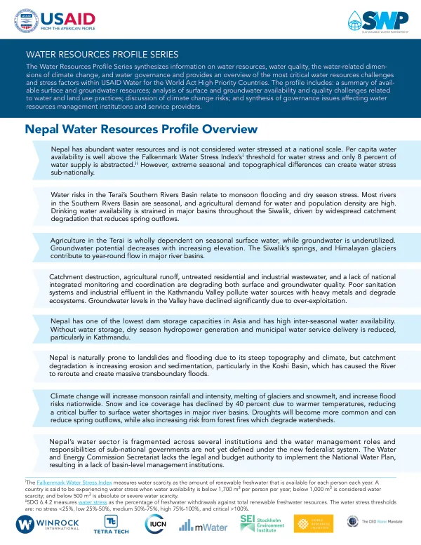
Nepal's water resources are characterized by abundant surface and groundwater availability, with per capita water availability well above the Falkenmark Water Stress Index's threshold for water stress.
2021 · 11 pages
Sign in to readA free account is required to download.
Abstract
However, extreme seasonal and topographical differences can create water stress sub-nationally. The country's water sector is fragmented across several institutions, and the water management roles and responsibilities of sub-national governments are not yet defined under the new federalist system. Catchment destruction, agricultural runoff, untreated residential and industrial wastewater, and a lack of national integrated monitoring and coordination are degrading both surface and groundwater quality. Poor sanitation systems and industrial effluent in the Kathmandu Valley pollute water sources with heavy metals and degrade ecosystems. Groundwater levels in the Valley have declined significantly due to over-exploitation. Agriculture in the Terai is wholly dependent on seasonal surface water, while groundwater is underutilized. Groundwater potential decreases with increasing elevation. Nepal has one of the lowest dam storage capacities in Asia and has high inter-seasonal water availability. Without water storage, dry season hydropower generation and municipal water service delivery is reduced, particularly in Kathmandu. The country's 3,252 glaciers provide 481 MCM in natural water storage in the Karnali, Gandaki, and Koshi Basins, while also sustaining over 5,000 lakes. Melting snowpack and glaciers provide around two-thirds of dry season flow for some rivers. The Terai's Southern Rivers Basin is prone to monsoon flooding and dry season stress, with most rivers in the region being seasonal and having high agricultural demand for water and population density. Drinking water availability is strained in major basins throughout the Siwalik, driven by widespread catchment degradation that reduces spring outflows. Climate change will increase monsoon rainfall and intensity, melting of glaciers and snowmelt, and increase flood risks nationwide. Snow and ice coverage has declined by 40 percent due to warmer temperatures, reducing a critical buffer to surface water shortages in major river basins. Nepal's water resources are organized and managed through five major basins: the Mahakali, Karnali, Narayani, Koshi, and Southern Rivers. Collectively, these basins provide 70 percent of the Ganges River's dry season flow and 40 percent of its annual flow. Most of the Karnali and Narayani Basins exist within Nepal, whereas the Koshi Basin's headwaters originate in the Tibetan Plateau in China and less than half of the Basin is in Nepal. The Southern Rivers Basin has the highest runoff, and includes lowland and hilly areas in central Nepal, including Kathmandu. The country's surface water is used for seasonal irrigation in the Terai, although it is also an important source of municipal water supply, including Kathmandu. Nepal lacks dam capacity to adequately cope with its high inter-seasonal water supply variability, limiting hydropower generation and municipal service delivery in the dry season. Land use changes are increasing erosion, sedimentation, landslides, and flooding in the Siwalik and Terai. Sedimentation is highest on the Koshi River and has caused the river to alter its course, resulting in extensive flooding.
Related documents