UNICEF
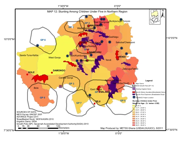
Map 12: Stunting Among Children Under Five in Northern Region
The Northern Region of Ghana is characterized by a diverse geography, with several districts and growth poles.
2011 · 1 pages
Sign in to readA free account is required to download.
Abstract
The region includes Bole, East Gonja, West Gonja, Yendi, Central Gonja, Karaga, Gushiegu, West Mamprusi, Sawla-Tuna-Kalba, Saboba/Chereponi, Nanumba North, Zabzugu/Tatale, Tolon/Kumbungu, Savelugu/Nanton, Nanumba South, East Mamprusi, Bunkpurugu-Yunyoo, and Tamale Municipal. These districts are grouped into nine growth poles (GP 1-9) as part of the Savannah Accelerated Development Authority (SADA) initiative. The region's geography is marked by a range of latitudes, from 7°30'0"N to 10°0'0"N, and longitudes, from 1°30'0"W to 0°0'0". The map produced by METSS Ghana in 2011 highlights several key locations, including major towns, existing irrigation dams, and areas for maize-soyabean and rice expansion. The ADVANCE Project location is also indicated on the map. Stunting among children under five is a significant concern in the region, with a prevalence of 13.70% in 2007, according to the MICS Survey conducted by UNICEF. The ADVANCE Project in 2011 reported a range of stunting prevalence rates across different districts, from 13.71% to 39.40%. The 'BreadBasket Study' conducted by MOFA/AGRA in 2010 identified areas for maize-soyabean and rice expansion, which are critical for food security in the region. The region's growth poles are designed to promote economic development and reduce poverty. The SADA initiative aims to accelerate development in the region by investing in infrastructure, agriculture, and other sectors. The growth poles are expected to serve as hubs for economic activity, creating jobs and improving living standards for local communities. However, the region still faces significant challenges, including high levels of stunting among children under five, which highlights the need for continued investment in healthcare and nutrition programs.
Related documents