FEWS NET
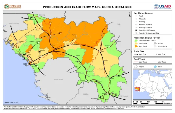
Production and Market Flow Maps: Guinea Local Rice
The agricultural development initiative in Rwanda was not the focus of this document.
2013 · 1 pages
Sign in to readA free account is required to download.
Abstract
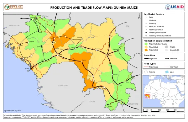
Instead, it appears to be a report on the production and trade flow maps of Guinea. The maps provide a summary of experience-based knowledge of market catchments and commodity flows significant to food security, particularly for basic grains and livestock. The production and trade flow maps were produced by FEWS NET and USGS in collaboration with local government, market information systems, and network and private sector partners. The maps were updated on June 20, 2013. Key market centers in Guinea include retail, wholesale, and assembly markets. The maps also categorize market centers by their function, such as assembly and retail, assembly and wholesale, and assembly, wholesale, and retail. The maps display production surplus and deficit data, with major production, minor deficit, and major deficit, as well as areas with no data or not applicable. Road types are also categorized, including major and minor roads. The maps also include regional and lake data, with kilometer markers ranging from 0 to 200 kilometers. Trade flow is another key aspect of the maps, with major and minor flow indicators. The maps provide a comprehensive overview of the production and trade flow dynamics in Guinea, highlighting key market centers, production, and trade flow patterns. This information is essential for understanding the country's food security situation and for making informed decisions on agricultural development initiatives. The maps are a valuable resource for policymakers, researchers, and other stakeholders interested in Guinea's agricultural sector.
Related documents