USAID DEC
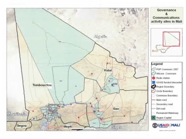
Governance & Communications activity sites in Mali
The governance and communications activity sites in Mali are primarily located in rural areas, with a focus on the PGP Commune 2007.
1 pages
Sign in to readA free account is required to download.
Abstract
This region is situated within the boundaries of a larger administrative region, which is further divided into smaller circles and communes. The main roads in the area are marked, with secondary and dirt roads also present. Permanent waterways are also visible, providing a source of water for the local population. The PGP Commune 2007 is a key location for governance and communications activities, with a region capital nearby. The commune boundaries are clearly defined, indicating the administrative divisions within the region. The main road passes through the commune, providing access to surrounding areas. Secondary roads and dirt roads branch off from the main road, connecting the commune to other nearby locations. The region is bounded by larger administrative boundaries, including circle and region boundaries. These boundaries define the administrative divisions within the region and provide a framework for governance and decision-making. The region capital is located within the region, serving as a central hub for administrative and governance activities. The governance and communications activity sites in Mali are focused on improving the delivery of services to rural communities. The activity sites are located in areas with limited access to basic services, including healthcare, education, and economic opportunities. The goal of the governance and communications activities is to improve the effectiveness of service delivery, increase access to information, and enhance the overall quality of life for rural communities. The region's geography and infrastructure play a critical role in the governance and communications activities. The presence of permanent waterways, main roads, and secondary roads facilitates the movement of people and goods, while the region capital serves as a central hub for administrative and governance activities. The commune boundaries and circle boundaries define the administrative divisions within the region, providing a framework for governance and decision-making.