USAID DEC
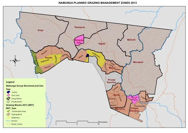
NA ABUNGA PLANNED GRAZING MANAGEMENT ZONES 2013
The Naibunga Planned Grazing Management Zones 2013 document outlines a conservation area in Kenya, specifically focusing on the Naibunga Group Ranches and surrounding land use.
2013 · 1 pages
Sign in to readA free account is required to download.
Abstract
The area is situated in the Laikipia region, known for its diverse wildlife and ecosystems. The document highlights the importance of planned grazing management in maintaining the ecological balance and promoting sustainable land use practices. The Naibunga Group Ranches are located in the Laikipia County, with the area covering approximately 100,000 hectares. The ranches are managed by various stakeholders, including the government, private landowners, and community groups. The document identifies several key land use types within the area, including government land, group ranches, private ranches, and conservation areas. The grazing blocks are designated based on the Naibunga Planned Grazing Management Zones 2013, with a total of 15 blocks identified. The document highlights the importance of conservation areas within the Naibunga Group Ranches. These areas are designated for the protection and conservation of wildlife and their habitats. The conservation areas are crucial in maintaining the ecological balance and promoting biodiversity within the region. The document also identifies several key features within the area, including roads, tracks, and rivers. Implementation of planned grazing management in the Naibunga Group Ranches is crucial in maintaining the ecological balance and promoting sustainable land use practices. The document highlights the importance of collaboration among stakeholders, including government agencies, private landowners, and community groups. The planned grazing management zones are designed to ensure that grazing is distributed evenly across the area, reducing the risk of overgrazing and promoting the health of the pastures. The document provides a detailed map of the Naibunga Planned Grazing Management Zones 2013, highlighting the location of the grazing blocks, conservation areas, and other key features within the area. The map is essential in understanding the spatial distribution of the grazing blocks and the conservation areas, and in planning for the implementation of planned grazing management practices.
Related documents
Documents in this collection
 2021
2021USAID DEC
Southern Africa Energy Program: Wildlife and Energy Interaction Program with Electricidade de Moçambique (EDM) Readiness Assessment by the Endangered Wildlife Trust
Open record 2019
2019USAID DEC
Creating Partnerships That Reduce the Impacts of Illegal Wildlife Trade on People, Elephants and Rhinos
Open record