STATE/PRM
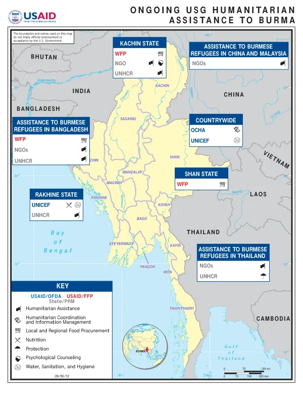
USAID-DCHA Burma Complex Emergency Program Map
The Sagaing Region in Myanmar is one of the country's 14 administrative divisions.
2012 · 1 pages
Sign in to readA free account is required to download.
Abstract
It is located in the northwest part of the country, bordering India and Bangladesh. The region is characterized by its diverse geography, with the Irrawaddy River flowing through it. The region's terrain is generally flat, with some hills and mountains in the north. The region is divided into 11 districts, including Sagaing, Bago, Magway, Mandalay, Ayeyarwady, Tanintharyi, Kayin, Rakhine, Yangon, Mon, and Shan. The districts are further divided into townships, with a total of 63 townships in the region. The region's population is approximately 5.9 million people, with a density of 143 people per square kilometer. The region is rich in natural resources, including forests, minerals, and water. The Irrawaddy River, which flows through the region, is a major source of water and supports agriculture and fishing. The region is also home to several major cities, including Sagaing, Bago, and Magway. These cities serve as commercial and administrative centers, with a strong focus on agriculture, trade, and industry. The region's economy is primarily driven by agriculture, with crops such as rice, maize, and beans being major contributors. The region is also home to several major industries, including textiles, food processing, and construction materials. The region's infrastructure is well-developed, with a network of roads, bridges, and ports connecting it to other parts of the country and the region. The region is also home to several major ethnic groups, including the Shan, Kayah, and Chin. These groups have their own distinct cultures, languages, and traditions, which are an important part of the region's rich cultural heritage. The region is also home to several major festivals and celebrations, including the Sagaing Festival, which is held annually in February. The region's humanitarian assistance is provided by several organizations, including the Office for the Coordination of Humanitarian Affairs (OCHA), UNICEF, and the United Nations High Commissioner for Refugees (UNHCR). These organizations provide assistance in areas such as food, shelter, water, sanitation, and hygiene, as well as protection and psychological counseling. The region is also home to several non-governmental organizations (NGOs), which provide assistance in areas such as education, healthcare, and economic development. The region's boundaries are defined by several major rivers, including the Irrawaddy, Salween, and Mekong. The region's climate is generally hot and humid, with a rainy season from May to October. The region's geography is characterized by its diverse terrain, with flat plains, hills, and mountains. The region's economy is primarily driven by agriculture, with a strong focus on crops such as rice, maize, and beans.